Overview
The Telegraph project, acquired in May, 2021, has a similar geological setting to major gold and copper-gold deposits in the Golden Triangle. Exploration this season included two phases of field work which added to the extensive historic database.
Project Summary
| Ownership | A) 60% option on the DOK propertyB) 100% interest in DOKX-YetiC) 100% in 12,934 stakedSee News release May 10th for full details |
|---|---|
| Size | 23,627 ha |
| Location | Located in the Liard Mining District in Northwestern BC’s Golden Triangle, 37 kilometres southwest of the town of Telegraph Creek. It is in the same neighborhood as a large number porphyry deposits including Galore Creek (Teck – Newmont), Schaft Creek (Teck – Copper Fox), Big Red (Libero Copper and Gold), Saddle and Saddle North (GT Gold – Newmont) and the operating Red Chris copper-gold mine (Newcrest – Imperial Metals). |
| Infrastructure | Access to the property is via helicopter or fixed wing plane to an airstrip on the eastern part of the claim block. The Stikine River, 3 km to the west of the property, is navigable from the ocean port of Wrangell, Alaska. The Barrington Road, from Telegraph Creek, comes to within 15 km of the northern part of the claims. |
Highlights
- Historic results suggest evidence of large-scale copper-gold porphyry potential.
- Consolidation of the prospective ground includes copper-gold soil geochemistry and airborne magnetic anomalies over a 6-kilometre trend.
- Property hosts 32 BC-minfile occurrences, including 6 prospects.
Early exploration on the DOK prospect outlined a large copper-in-soil geochemical anomaly referred to as the Main zone. The northwest trending anomaly is greater than 1,200 metres long, and is open along strike in both directions. In 1971, approximately 500 soil samples were collected. More than 20% of the samples yielded values of copper greater than 400 ppm, with a significant number of samples exceeding the upper detection limit of 2,000 ppm. The soil anomaly occurs in an area with less than 5% bedrock exposure. Copper mineralization discovered on the DOK prospect is described as occurring as disseminations, patches, blebs, and fracture fillings, as well as local quartz-carbonate-sulphide (pyrite, chalcopyrite) veins and vein stockworks associated with relatively intense iron-carbonate alteration (Rowe and Greig, 2016). The copper mineralization is associated with fine-grained alkalic intrusive rocks such as those exposed at the Schaft Creek, Galore Creek and Red-Chris porphyry deposits.
Drilling from 2014 on the Main zone demonstrated the presence of broad intervals of low to moderate grade copper-gold-silver bearing stockwork-style mineralization hosted within potassically-altered volcanic rocks and syenitic intrusions.
The DOK Main zone has had the most historic exploration to date, including the only drilling. There are a large number of pyritic gossans scattered across the DOK and DOKX options that have had little exploration work on.

Figure 1: Telegraph Claims with acquired and staked ground. Stars represent Cu-Au soil geochemistry anomalies and mineral prospects
Prior Work
The property area has received sporadic exploration by numerous companies over the past five decades, including silt, soil and rock geochemistry, geological mapping, geophysics and minor drilling. The property hosts 32 BC-minfile occurrences, including six prospects, the DOK, DOK 35, Yeti, Blizzard, Steep Creek, and Canyon 24.
The DOK prospect is the most advanced exploration target on the property. The neighboring DOK-35 prospect is considered part of the same mineralizing system. Both the DOK and the DOC-35 prospects have mineralized outcrop grab samples and channel samples, soil geochemical anomalies, and corresponding airborne geophysical magnetic and radiometric signatures that suggest a porphyry mineralized system. The Mountain Boy Minerals consolidation has joined these two prospects that were historically explored by separate companies. A 6-kilometre-long copper-gold mineralized trend is centered on the boundary between the two properties (Figure 1).
The DOK prospect was first explored in the early 1970s with a focus on copper. That work identified numerous copper showings and outlined a substantial copper-in-soil geochemical anomaly referred to as the Main target, 1,200 meters by 850 meters in size. Hand trenching near the upslope edge of the Main target geochemistry anomaly uncovered bedrock exposures of volcanic strata mineralized with stockwork and disseminated chalcopyrite, pyrite and minor bornite. An airborne qeophysical survey in later years identified coincident magnetic anomalies. The trenches were chip sampled in 1971 and the Main target was drill tested with five holes in 1972, totaling 817 metres and two holes in 2014, totaling 835 metres. The 1972 work was not filed for assessment and the data is not available. The 1971 trenching and the 2014 drilling demonstrated that the system hosts copper and gold mineralization. Results from the 1971 trenching include 0.66% Cu over 38 metres, 0.32% Cu over 23 metres and 0.72% Cu over 15 metres. Gold was not assayed for in 1971. The drilling that took place in 2014 was targeted based on soil geochemistry, magnetic data and induced polarization chargeability high anomalies. Results from the 2014 drilling include 0.327% Cu, 0.13 g/t Au and 1.92 g/t Ag over 18.3 metres and 0.113% Cu, 0.06 g/t Au and 1.64 g/t Ag over 54.9 metres. Both of these holes contain broader intervals of lower-grade copper-gold-silver mineralization. In the 2015 assessment report on drilling, Jeffrey D. Rowe and Charles J. Greig state “the presence on the DOK property of broad intervals of low to moderate grade Cu-Au-Ag stockwork-style mineralization in drill holes, extensive soil geochemical anomalies and coincident magnetic and IP chargeability highs, within areas of potassically-altered volcanic rocks and syenitic intrusions are all indications of an extensive porphyry-style mineralizing system, within which the potential for discovery of a substantial Cu-Au-Ag deposit remains high. Further exploration work is definitely warranted”. (AR35798).
There is no record of drilling on any other parts of the Telegraph property, in spite of the numerous highly encouraging surface samples and the favorable geological setting. The Mountain Boy geological team concludes that the Telegraph property has not been adequately explored.
Geology
The property is underlain by Upper Triassic Stuhini Group volcanic rocks (Figure 2), which are unconformably overlain by Lower to Middle Jurassic Hazelton Group volcanic rocks. This Stuhini to Hazelton transition has been referred to as the ‘red line’ and represents a time in the earth’s history when a lot of deposits in B.C. were forming. The unconformable contact is marked by locally very thick and very coarse-grained polymictic boulder conglomerate beds (Rowe and Greig, 2015) which is of major significance because it suggests that the property likely hosts basin bounding structures which act as the conduits for intrusions and their mineralizing fluids with the potential of generating significant mineral deposits in the vicinity.
The volcanic package is intruded by several different phases of Late Triassic to Early Jurassic intrusions. They include plutons of the “Copper Mountain suite” aged 210-195 Ma, the “Texas Creek suite” aged 195-189 Ma, the “Cone Mountain suite” aged 187-180 Ma and the “Three Sisters suite” aged 177-170 Ma. The Copper Mountain suite is associated with many Cu-Au deposits in the area including Galore Creek. The Texas Creek and related suites are associated with many of the deposits in the Premier and KSM camps including the Silbak, Big Missouri, KSM and Brucejack deposits.

Figure 2: a) Property Geology (after Massey et al., 2005, and Greig and Flasha, 2009)
There are several major structures identified on the property and include regional thrust faults in the northeast and northwest. Large gossanous hydrothermal alteration zones have also been noted throughout the property.
In summary, the geological setting of the property is similar to the settings of the major gold and copper-gold deposits in the Golden Triangle. The Telegraph project has the potential to host the next major discovery in the Golden Triangle.
Geophysics
An airborne geophysical survey of magnetics and radiometrics was flown on the DOK (1508 line-km) and DOKX property (47 line-km) in 2011 and 2018, respectively. The interpretation of the total magnetic intensity (TMI) and the calculated vertical gradient of the magnetic field (CVG), as documented by Stewart (2011) shows the following features (Figure 3):
- The TMI and CVG data has defined five large, strong, positive signatures within the property,
- Two of the TMI and CVG anomalies correlate with the two large previously identified copper-gold-molybdenum-silver in soil geochemical anomalies,
- The TMI and CVG signatures that coincide with the larger of the two geochemical anomalies suggest that this soil anomaly could extend at least an additional 1,000 metres to the northwest.
- The TMI and CVG data has also outlined a large, magnetic high, semi-circular anomaly in a previously unexplored area of the property.
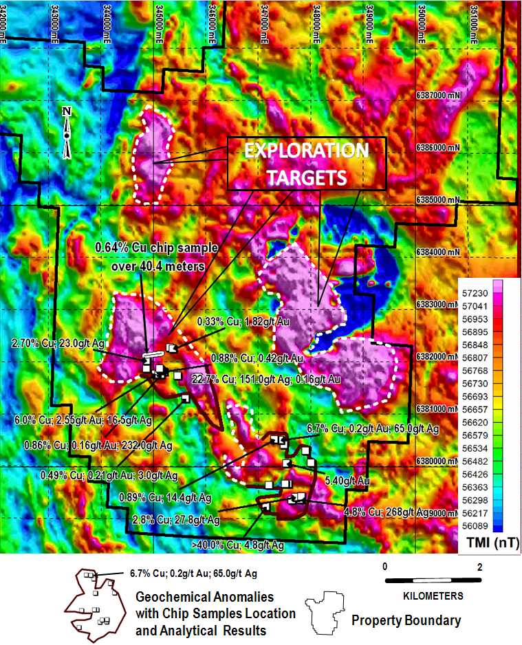 Figure 3 DOK option Airborne Survey Total Magnetic Intensity (TMI) Interpretation
Additionally, a magnetotelluric (MT), direct current and resistivity (DC), and induced polarization (IP) survey was performed by Quantec Geoscience Ltd over portions of the DOK option in 2012. The survey included 5 DCIP & MT spreads along 5 NE‐SW oriented survey lines with 100 m station interval (along the slope). A total of 8.4 km of DCIP survey (8.7 km with current extension) and 8.4 km of MT survey were surveyed. A pole‐dipole configuration was used for DCIP measurements.
Further Work
Main Zone
- Further Induced Polarization (IP) geophysics of the Main Zone area.
- Detailed identification and characterization of the alteration assemblage in historic drill core and hand samples.
- Drilling of identified targets.
Other Areas
- Leveling of the all the airborne geophysical survey data sets from the DOK and DOKX options so as to be able to look at the data as a single set.
- Follow up of targets southeast of the Main Showing with identified Cu-Au-Ag mineral showings, soil geochemical anomalies and magnetic highs.
- Follow up of other geophysical targets identified by Stewart (2011, 2014)
- Follow up of identified radiometric potassium anomalies.
- Continued reconnaissance exploration, such as stream sediment sampling and prospecting across the remainder of the property with the aim of identifying areas of high exploration potential.
- Drilling of identified targets.